Bay Area Overview > The Peaks > Mount Saint Helena

At 4,341 feet in elevation, Mount Saint Helena in the Mayacamas mountains is the tallest peak in the Bay Area Six-Pack, and one of the few mountains in the Bay Area to actually receive snowfall in the winter.
Mount Saint Helena Basics
- Summit elevation: 4,341′ (1,323 m)
- Vertical gain: 2,119′
- Hiking mileage: 10.7 miles
- Trailhead Location: Robert Louis Stevenson State Park
Hiking Mount Saint Helena from Robert Louis Stevenson State Park
Trail Guides
Here is a detailed trail guide to give you the information you need about this route:
St Helena & Wine Tasting
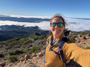
Gorgeous hike and incredible views. After one mile you get amazing views and hiking above the fog layer. It was a clear beautiful day and

Autumn Hike
Lots of yellow leaves in the trees and orange leaves in the ground during the first mile. Perfect weather with just enough clouds to keep

Mount Saint Helena
It was a gorgeous Fall day for a hike up Mount Saint Helena. Cool in the morning and warmed up to a pleasant 79. As

Mount St. Helena (and Table Rock)
Another beautiful day to be out hiking in the Bay Area! I climbed the West Peak (the one that this challenge is for) and added
Mt. Saint Helena
Parking lot off the side of the road is easy to miss. Trail is well maintained.

Mt. St. Helena
Easy gradual uphill mostly on a fire road. Perfect weather, sunny but cool. There were many climbers but hardly any hikers. We started at 9am
The Bay Area Six-Pack of Peaks Challenge
![]() This hike is part of the San Francisco Bay Area Six-Pack of Peaks Challenge, a series of challenging hikes up six, diverse and scenic Bay Area mountains. Sign-up to take the challenge today!
This hike is part of the San Francisco Bay Area Six-Pack of Peaks Challenge, a series of challenging hikes up six, diverse and scenic Bay Area mountains. Sign-up to take the challenge today!
Got a link, tip or favorite aprés-hike restaurant we should add to this page? Let us know!