One Membership. All Challenges. Your Adventure Starts Here.
THE PEAKS OF THE Pacific northwest CHALLENGE
MOUNT SI – Elevation 4,114′ (1254 m)
This popular hike is steep, but rewards with stunning views of the Snoqualmie River Valley. A Discover Pass is required for parking at the trailhead.
Note that the final scramble up The Haystack to the true summit is optional.
Six-Pack Route Details: Mount Si Trail Distance: 7.5 miles; Vertical +/- 3,336 ft.
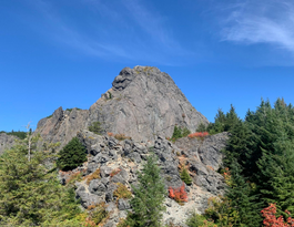
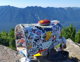
MAILBOX PEAK – Elevation 4,841′ (1476 m)
Take the old trail and you'll climb over 4,000 vertical feet in less than three miles. Fortunately, there is a longer-but-kinder new trail with switchbacks. With that vertical gain, either option is a physical challenge.
Mount Ellinor stands nearly 6,000′ above sea level, a prominent sentinel at the south-eastern corner of the Olympic Peninsula. The trail up Mt. Ellinor has a reputation for being steep, but rewarding with terrific views.
Six-Pack Route Details: Hiking Mount Ellinor Distance: 6.6 miles; Vertical +/- 3,286 ft.
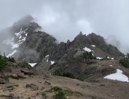
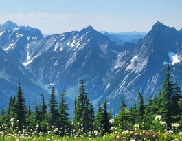
GRANITE MOUNTAIN – Elevation 5,629′ (1716 m)
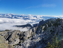
A steep climb up the south-facing slope of Granite Mountain might reward you with wild huckleberries. The views from the top are legendary – one of the reasons there is still an active fire lookout tower at the summit.
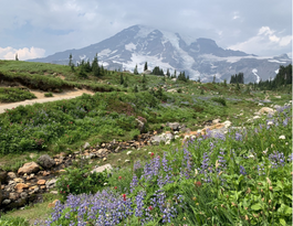
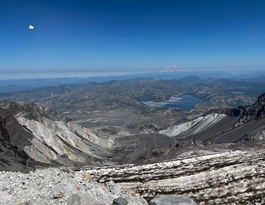
Nestled between the Nisqually and Paradise Glaciers on Mount Rainier, Camp Muir is the highest point on the mountain that you can reach without a climbing permit. And you'll get some snow travel up the Muir snowfield above Paradise.
Climbing to the top of this active stratovolcano is challenging, but won't require any technical skills, but it does require a permit, so apply early.
For 2021, climbing permits will be made available on the first of each month at 7:00am PST for the following month. This new process will remain in place throughout the permit quota season, ending October 31, 2021. Climbing permits cost $15 per person per day. A $6 reservation fee is charged per transaction.
For 2023, there are four alternate peaks. If you choose, you can replace any of the six peaks above with any these mountains.
MOUNT DICKERMAN – Elevation 5,729′ (1746 m)
Located off Mountain Loop Highway in the Mt Baker – Snoqualmie National Forest, this is a steep out-and-back hike, climbing an average of nearly 1,000 feet per mile. Renown for wildflowers and bird watching.
Six-Pack Route Details: Mount Dickerman Trail Distance: 8.3 miles; Vertical +/- 3,854 ft.
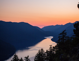
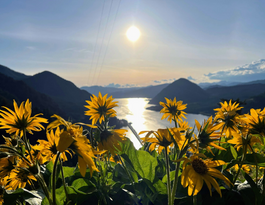
MOUNT STORM KING – Elevation 4,538′ (1383 m)
Mount Storm King is a challenging hike with a little of everything; steep switchbacks, a rope section and a rock scramble to the summit. This peak towers over Crescent Lake.
There is a fee to enter Olympic National Park.
Six-Pack Route Details: Mount Storm King Distance: 5.3 miles; Vertical +/- 2,076 ft.
MOUNT DEFIANCE – Elevation 4,935′ (1504 m)
This six-million year old shield volcano is the highest point of the Columbia Gorge, and is considered by some to be “the hardest hike in Oregon”. Lots of vertical, but you'll be rewarded with front seat views of the Columbia Gorge, Mount Adams and Mount Saint Helens.
Six-Pack Route Details: Mount Defiance Trail Distance: 12.4 miles; Vertical +/- 5,072 ft.
MOUNT PILCHUCK – Elevation 5,341′ (1629m)
Mount Pilchuck is a very popular hiking destination in the North Cascades despite the difficult, rocky climb to the top. The historic lookout tower is part of the appeal, but the real attraction are the million-dollar views.
Six-Pack Route Details: Hiking Mount Pilchuck Distance: 5.5 miles; Vertical +/- 2,300 ft.
The Peaks: PNW Six-Pack of Peaks
Report
There was a problem reporting this post.
Block Member?
Please confirm you want to block this member.
You will no longer be able to:
See blocked member's posts
Mention this member in posts
Invite this member to groups
Message this member
Add this member as a connection
Please note:
This action will also remove this member from your connections and send a report to the site admin.
Please allow a few minutes for this process to complete.