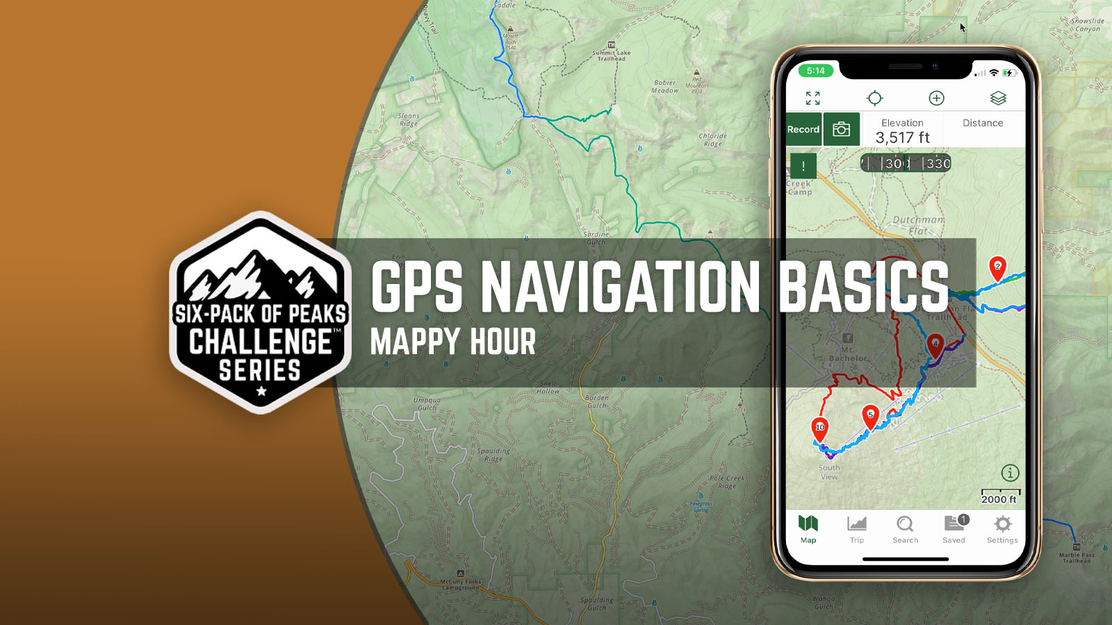
GPS Navigation Basics
GPS has become an essential tool for hikers, whether planning a route, tracking their route, or navigating along the way. In this short recording, I walk through the basic process I use to help plan a route on my computer, preparing my smartphone before I leave home, and using my smartphone while on the trail.
In the video demonstration I use GaiaGPS with the “pro” subscription, both on my computer and on my iPhone. Many of the same concepts apply to other apps or websites such as AllTrails, though the interface will be different.
First Things First
Anytime I’m hiking into the backcountry or a wilderness area, I carry a paper map. You can print maps from GaiaGPS, AllTrails, or Caltopo.com, but my personal preference is a waterproof, tear resistant foldable map for the area I’ll be hiking. There are a number of map makers that do these, usually based on the region. Harrison Maps are one example.
Why carry a paper map? It’s the quickest way to get the big picture of an area. It never runs out of battery. And a good map will include point-to-point mileage between junctions, trailheads and points of interest. Map and compass navigation goes beyond the scope of this short video, but if you’re interested in learning more, I recommend the book Wilderness Navigation: Finding Your Way Using Map, Compass, Altimeter and GPS by Mike and Bob Burns, published by Mountaineers Books.
Route Planning
I do most of my route planning on my laptop using the GaiaGPS website. The layers in GaiaGPS give you access to a wealth of options, including historical and current wildfires, snow depth, historical, public and private lands. Map layers can be reordered and you can set the opacity level to allow you to see multiple layers at once.
GaiaGPS has route creation tools that will “follow” known trails, allowing you to quickly snap to trails and create routes with just a few clicks. The resulting route will include the elevation profile, total mileage and other details, and you can view on your mobile device with the GaiaGPS app.
Before You Go
Before I leave home for my hike, I download the maps that I’ll need on my iPhone. It’s important to do this because many trails have spotty or no cell service. Having the maps downloaded before you leave home means you’ll be able to see the maps while you’re on your hike, even with your phone in airplane mode.
Also before you go, make sure your phone is fully charged. If you’re bringing a power brick, make sure that’s also fully charged (and that you have the charging cable).
Finally, I’ll open the app to get driving directions to the trailhead. Both GaiaGPS and AllTrails offer this feature, launching your driving maps of choice (usually Apple Maps via CarPlay for me).
On the Trail
I typically will use GaiaGPS to record my hike. This way, I’ll not only have the stats on how far I’ve hiked and how high I’ve climbed, but I’ll also have a the data for later reference. Most trails that are well-marked and well-signed won’t require me to look at the map on my phone unless I want to check my position. It can be really handy when navigating over snow!
GaiaGPS and other apps also provide directions when following a downloaded route. I don’t typically use this, but it can also be useful just to see if you’re where the app thinks the trail should be.
Questions?
If you have questions about anything from the video, please post a comment below and I’ll do my best to get you an answer.


Thanks for this video and blog post! I’ve been using the AllTrails app for the past couple of years and love it. However, I noticed that when I was backpacking and camping for a couple of days in the backcountry that when I wanted to use my AllTrails app to look at surrounding areas and other possible day hikes, it was limited in its ability to do so. I also like the overlay features I’m seeing in your video like for snow and smoke from fires. I’d like to continue using AllTrails app for tracking my hikes but also considering using Gaia GPS as a back up and for the other features I’ve listed above. Can it be helpful to have BOTH apps for these purposes or should I just ditch AllTrails and upgrade to Gaia GPS? Do you have a sense of how common it is that hikers use both apps?
Great point, James. I have both. I personally prefer GaiaGPS for tracking and navigating when I’m in the backcountry, especially backpacking. I like that I can specify a region and download multiple map layers for that area for offline navigation.
AllTrails excels at finding trails and getting reviews, though you have to take those with a grain of salt. We held a Happy Hour in May 2023 where we walked through AllTrails, which is probably more popular for day hikers and more casual trail discovery. There is a place for both, though if you really wanted to, you could probably get by with either.
Thanks for the extra information about both apps Jeff! I’m gonna go ahead and add Gaia GPS to my navigation system so I can have the best of both worlds. Thanks again for all you do!