The Sixth annual

Arizona Winter Six-Pack of Peaks Challenge

Registration Now Open

Piestewa Peak Overview

PIESTEWA PEAK– Elevation 2,608′ (795 m)

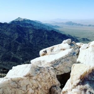
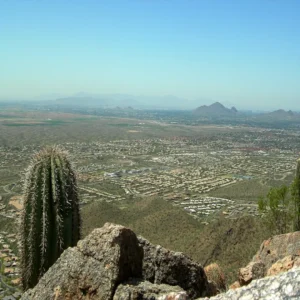
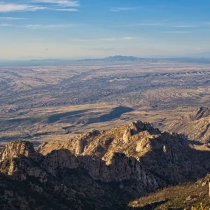
The second tallest in the Phoenix Mountains, Piestewa Peak has a lot to offer considering its location and length. It has great views into the rest of the Phoenix Mountain Range and into the city of Phoenix. It has easier flat sections, challenging steep sections, and a short scramble to the true summit.

Six-Pack Route Details: Hiking Piestewa Peak in the Phoenix Mountains Preserve
Distance: 2.2 miles; Vertical +/- 1,112 feet

Six-Pack Alternate Route Details: Hiking Piestewa Peak from Dreamy Draw
Distance: 6.6 miles; Vertical +/- 1,760 feet

CAMELBACK MOUNTAIN – Elevation 2,707′ (825 m)

Camelback Mountain is the most popular mountain to hike in the Phoenix area for good reasons. It’s a fun challenging hike from either side, it has good views of the Phoenix area, and it’s entertaining to compare its profile to a napping camel.

Six-Pack Route Details: Hiking Camelback Mountain via the Echo Canyon Trail
Distance: 2.4 miles; Vertical +/- 1,400 feet

Six-Pack Route Details: Hiking Camelback Mountain via the Cholla Trail (re-opened with new trailhead)
Distance: 2.8 miles; Vertical +/- 1,246 feet

PICACHO PEAK – Elevation 3,374′ (1,028 m)

Picacho is one of those peaks that you look at and can’t tell how there’s possibly a trail to the top, so it’s no surprise that this is one of the most exciting two and a half mile hikes out there. Once you make it beyond the halfway saddle, it’s a rollercoaster of a mountain and emotion. You’ll be thankful for the system of steel cables there for you to cling to along all the steep, bare rock sections.

Six-Pack Route Details: Hiking Picacho Peak via the Hunter Trail
Distance: 2.4 miles; Vertical +/- 1,986 feet

FREMONT SADDLE – Elevation 3,766′ (1,148 m)

Peralta Canyon gives access to one of the most breathtaking views in Arizona. At Fremont Saddle, you’ll have a spectacular vantage point of a massive and surprising monolith. Often playing a role in stories of the Lost Dutchman’s Gold Mine, Weavers Needle is a 1,000 foot column of rock that protrudes impressively from the surrounding desert landscape.

Six-Pack Route Details: Fremont Saddle via Peralta Canyon
Distance: 4.8 miles; Vertical +/- 1,496 feet

WASSON PEAK – Elevation 4,687′ (1,429 m)

Wasson Peak is the tallest mountain in the Tucson Mountain District of Saguaro National Park. This loop hike travels along ridges with grand desert vistas and through some of the thickest Saguaro forest in Arizona.

Six-Pack Route Details: Hiking Wasson Peak in Saguaro National Park 
Distance: 7.7 miles; Vertical +/- 1,886 ft.

FLATIRON – Elevation 4,871′ (1,485 m)

Located in Lost Dutchman State Park of the Superstition Wilderness, Flatiron is one of the most challenging and spectacular hikes in Arizona. The Siphon Draw Trail brings you passed towering rock formations, up a basin carved smooth by water, and tops out on one of the most iconic rock formations in the Southwest.

Six-Pack Route Details: Hiking Flatiron via Siphon Draw
Distance: 6.6 miles; Vertical +/- 3,147 feet

Alternate Peaks

For 2024, Quartz Peak, Sunrise Peak, and Mount Kimball have been designated optional alternate peaks. If you choose, you can replace any of the six peaks with any of the alternate peaks, or hike them all for an extra challenge.

QUARTZ PEAK – Elevation 4,052′ (1,235 m)

One of the highest points in the Sierra Estrella Wilderness, Quartz Peak offers spectacular views from atop a unique summit block made of white quartz. This challenging trail has beautiful vistas of the Rainbow Valley as it climbs a rugged ridge from the valley floor to the crest of the Sierra Estrella.

The road conditions to Quartz peak have deteriorated and we only recommend attempting this summit if you have a high clearance vehicle and off-roading experience. Check recent hike logs for more information from fellow challengers.

Six-Pack Route Details: Hiking Quartz Peak in the Sierra Estrella Wilderness
Distance: 6 miles; Vertical +/- 2,400 feet

SUNRISE PEAK – Elevation 3,068′ (935 m)

Sunrise Peak is near to town and offers some of the best sunrise views around. The last quarter miles to the summit is very steep and will leave you huffing and puffing while enjoying the view

Six-Pack Route Details: Sunrise Peak via Sunrise Trail
Distance: 4.3 miles; Vertical +/- 1,184 feet

MOUNT KIMBALL – Elevation 7,262′ (2,213 m)

Mount Kimball is considerable higher than any of the other peaks of the Arizona Winter challenge. You will have to keep an eye on the hike logs from your fellow challengers to avoid snow and ice, or be prepared for some winter mountaineering. Gaining 4,200 feet over the 9.5 miles out and back, Mount Kimball is a hard summit that rewards with views of the Pusch Ridge Wilderness.

Six-Pack Route Details: Mount Kimball via Finger Rock Trail and Pima Canyon Trail
Distance: 9.5 miles; Vertical +/- 4,250 feet

Sunrise Peak photo by al_hikesaz and Mount Kimball Photo by Chris Rycroft.

AZ Winter 20% off early-bird rate ends in

:
:
: