
San Bernardino Peak
About this peak
One of the best-kept secrets of Southern California is San Bernardino Peak, just five miles from San Gorgonio and a respectable 10,649 feet. The route climbs from Angelus Oaks, about 16.5 miles round trip with roughly 4,700 feet of gain, on well-built switchbacks through oak and pine, then past Limber Pines and Washington’s Monument, the 1852 survey point from which Southern California was mapped, to the summit. It’s a long day at altitude, so start early and carry plenty of water.
Know before you go
Hazards
Very long day: about 16.5 miles and 4,700 feet of gain. Dehydration and altitude are the main risks, so carry plenty of water and electrolytes; the small creek about half a mile before Limber Pines is seasonal and should not be counted on from mid-summer. Large snow patches can cover the upper trail in spring and early summer. Check the message board at the trailhead for ranger notices such as rattlesnake sightings.
Join the Community to view parking and routes
Members get route details, parking and trail guides, and can log hikes toward badges.
Join the CommunityAlready a member? Log inHike logs from this peak
Log your hike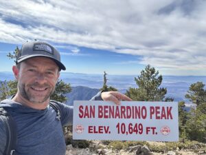

More peaks in this challenge
Sorted by elevation. Bars show summit elevation against the highest peak.
- San Gorgonio 11,503 ft
- Mount San Jacinto 10,834 ft
- San Bernardino Peak (you are here) 10,649 ft
- Mount Baldy 10,064 ft
- Mount Baden-Powell 9,406 ft
- Cucamonga Peak 8,859 ft
- Sawmill Mountain 8,822 ft
- Ontario Peak 8,696 ft
- Strawberry Peak 6,164 ft
- Mount Wilson (San Gabriel Mountains) 5,713 ft
- Santiago Peak 5,689 ft
- Sitton Peak 3,273 ft